
“It’s at this point I learnt that the CWT is the Buckaroo of long Distance Paths; you know for sure that the path is going to turn to a boggy, hellish quagmire – you just don’t know when!”
Route


Unfortunately there was not enough time to cover the entire trail as we only had 7 days dedicated to the actual CWT – the rest of the time was needed to get to/from trailheads and back home. With that in mind we picked the circa 150 miles from Achnashellach to Cape Wrath. Deviations from the above:
- We actually started from Achnashellach rather than craigs because I can’t read maps!
- We cut across the tops to Inverlael rather than stay in the bothy on day 2.
- We carried on to Kylesku on day 5.
- On Day 7 we finished at Kearvig bothy
We were self contained with 8 days worth of food (which weighed a LOT on the first few days) with some extras thrown in just in case as there were no real shops on the way until the last day. We also had water filters rather than iodine tablets – although I always carry a few of these to spare. On this trip we also carried (relatively) light weight solar panels to power GPS etc. The journey up to the trail by four out of four trains being late across two days and, to add insult, it started hammering it down at around 15.30 when we set off to cover the 10 miles to Kinlochewe.
Day 1 – circa 11 Miles – Anchnashellach to Kinlochlewe
I actually should have had us get off at Craig, but the paths joined up so it was pretty straight forward to get onto the trail. The path started off pretty well and I was buoyant to be walking albeit knowing there were many miles ahead. This was particularly true of this walk as I had adopted Andrew Skurka’s ultra lightweight trail shoe (Inov8 Roclite 295’s in my case) method of walking which just accepts you are going to get wet feet and is all about caring for your feet at the end/start of the day so they don’t fall off. This easy start, typical of the trail, turned to muddy woodland pretty soon and carried on in this way all the way to the end. It cross my mind what I’d let myself in for especially when the going got really rough at the end with vegetation up to our heads and my friend trying his level best to drown himself on a river crossing. We arrived and found Kinlochlewe had a hotel so tested the beer wasn’t poisoned before camping in the centre of the small settlement being eaten alive by midges. Another success of this first day was our self dehydrated food (avoiding the extortionate £5 meals you get in outdoor shops) were excellent and filling.
Day 2 – circa 28 Miles – Kinlochlewe to Inverlael
The midges were out again in force – I had foolishly dismissed my Avon Skin So Soft as being no good at this point and just danced about swearing at them. My friend cheerily informed me the can get “1000 times” worse – which didn’t really cheer me up. As we set off the weather was damp, but not awful we were starting our first full day in earnest along a good path through a wonderful glen by a typical highland river. The path wound up to some highland lochs and then the path just disappeared. It’s at this point I learnt that the CWT is the Buckaroo of long Distance Paths; you know for sure that the path is going to turn to a boggy, hellish quagmire – you just don’t know when! The path went straight up to a rocky col through muddy, boggy ground and didn’t take it’s time – this was a tough pull with 15kg rucksack pulling you the other way. After this we were in an amazing highland valley where we picked out way through am uneven descent before winding it’s way along a river where, by rights, we should have finished for the day (people generally do), but we needed to get ahead of the game and tacked on another day which took us over two climbs and yet more rough, boggy ground. We didn’t arrive until after 8 in Inverlael having being walking for 12 hours or so. We camped in a forest and were totally devoured by midges (it’s now over a week later and I’ve got scars still) which made me cower in the tent grabbing my breakfast so I wouldn’t have to get out in the morning. I worked out I wouldn’t read much on this trip as I just passed out until around 7am.


Day 3 – Circa 22 Miles – Inverlael to Oykel Bridge
We had to immediately climb up through forest tracks with, for a walker, a surfeit of switchbacks. Both of us were dehydrated, but there were no streams to be had and we had to get to around 650 metres before coming to a very pleasant river and I drank 2 litres of water and then made a coffee. Suitably refreshed we were then instantly punished by the path turning to bog. Well the path didn’t turn to bog – there was no path we were just walking in bog. This was the day I got used to having wet feet and trusted the method as despite them being wet I was not getting rubbing and therefore no blisters. Happily this remained true of the entire trail. We walked through rough, boggy ground over rivers (you get used to river crossings very quick here!) and past raging cataracts. I remember being so happy to be in Scotland in an area most people have not seen and, for a little while, with shining sun. Then we came to a isolated loch with a lonely, rusty boathouse which reminded my friend of Iceland and me of Norway. After a while we were treated to a path which persisted all the way to Oykel Bridge. Here was another Hotel with a bar (you don’t tend to get pubs as such in Northern Scotland) where we unwound before camping a mile or so along the route of the beautiful River Oykel.


Day 4 – Circa 23 miles – Oykel Bridge to Inchnadamph
This was a tough morning. The weather was very wet and the path along the river was persistently wet. I couldn’t seem to get going and despite ramming my face with all the sweets and nuts I could find I just couldn’t shake the feeling. It was probably just getting used to the routine of things looking back, but it stayed with me until after lunch. Along the river were quite a lot of well heeled salmon fishers resplendent in tweed and fine wooden poles. It really wasn’t the day to be stood still in a river, but they seemed happy and one fellow took his pipe out of his mouth to tell me, “good walking pace there” as I grinned and walked past him. Pushing on to the Benmore-Assynt area where the scenery got a lot more dramatic and, after being on the flat, some climbs sorted me out and I felt exhilarated with fantastic views and very happy to be here. There were some pretty sketchy paths here – probably sheep tracks in truth – where a slip would probably have been a very bad thing. It took us quite a while to negotiate the valley down to Inchnadamph and, to mock us, the sun started shining. We had the last laugh because there was, again, a Hotel Bar.


Day 5 – Circa 26 miles – Inchnadamph to Kylesku
A beautiful morning with a slight breeze to keep the midges away welcomed us and I was ready to get going. We climbed up that perfect gradient which you could walk up all day long to a high, stony corrie complete with a few lochs. The path then led us over scree to a stony pass and absolutely amazing views of Assynt. This felt like hill walking to me – that’s very much my wheelhouse – and after a few days on the trail using food the packs didn’t feel as heavy and it was a lot of fun to walk on. A steep descent took us down past erratics and eventually to boggy ground opening up to views of the spectacular Eas Chual Aluinn Waterfall. The path wasn’t great – well it wasn’t a path, but that didn’t bother me as I was in good spirits still. We lunched by a sea loch in great weather before we climbed over a pass and the good going and good weather left us for a while. The path was treacherous here where a slip would have seen you fall into a loch 100 metres below inspecting rocks very closely on the way. The wind and rain were not making things easy and we made our way carefully to the Glendhu bothy for a break before using a 4X4 track and road to Kylesku and a very nice bar/restaurant.


This was my favourite day on the trail.
Day 6 – circa 22 miles – Kylesku to Rhiconich
This was my least favourite day on the trail.
All night a storm blew us to bits as we camped by a sea loch. I didn’t sleep a wink and felt dreadful with eyes extremely heavy the day stretched out impossibly before me. We got started and climbed steadily to about 500 metres with the wind thrashing us all the time. We had to cross a fell around 550 metres and the gusts were extreme and easily gale force. I got blown over by it into bog and I swore heartily. Hill fog was making navigation almost impossible and it was tough going with energy levels so low. Battling down to lower levels we came to rough paths in a pleasant setting where we snacked and gathered thoughts before dropping down on good 4×4 paths. I’d learnt at this point that unless someone happened to, at some point, want to travel from a to b using a 4×4 the path would be total rubbish. I started to get giddy thinking this would take us all the way when the track messed off at roughly 180 degrees to where we were heading. We then had to negotiate the worst bog of the walk. I mean really bad bog that was basically a pond interspersed with river crossings made more difficult by the fact they were in spate from the storm that had plagued us in various forms for the past 24 hours. We were walking all over the hill side trying to find suitable routes and it was very tiring. After about three hours of this we got on a better track and into a town. At this point the sun had started shining and we found a nice sheltered camping spot and, after a couple of pints (can you see the pattern?) we slept like the dead.

Day 7 – circa 27 miles – Rhiconich To Kearvig Bothy via Cape Wrath.
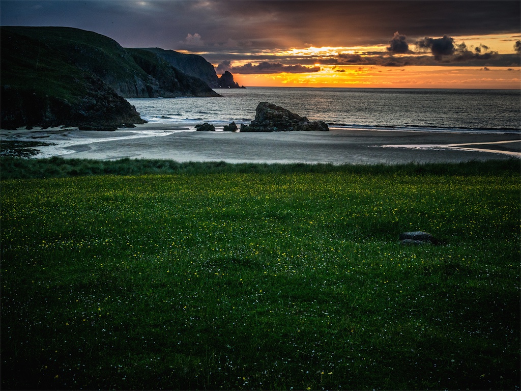
The last proper day on the trail had ticked round and it was a corking day. The sun was beating down and I had to put sun cream on! We found a bone fide shop and bought snacks with the alacrity of school children misspending lunch money. Soon finding ourselves on a fine path to Sandwood Bay and making great time and I started reflecting on the fact I’d probably finish okay unless the MOD had left a few stray mines somewhere in Cape Wrath. Sandwood Bay is glourious and must be one of the best beaches in the UK. It’s unspoilt because the only way you can really get there is a 9 mile return trip on foot which is like telling most people to walk to the moon. So it’s probably good it’s remote and, like Cornish beaches, will stay in this state for as long as geography rather than people will allow it. I was nervous about the next 8 miles as I’d heard about the bogs and trackless terrain. However, it was no different to paths I’d walked on previously and a damn sight better than the previous day. The route undulates quite a bit so it was tiring, but the sun persisted and we could sense our quarry. A path guided us round to the lighthouse where we took a few snaps and had the most welcome cup of tea and cheese and pickle sandwich ever ever. The walk to the bothy was straight forward on very good paths and the bothy itself felt like the real end to the walk as it was in a stunning location and having been recently renovated very homely.


The next day we walked along the track 10 miles or so to catch a ferry (who wasn’t expecting us so we were lucky) across the firth to Durness and then a bus to Inverness. All in all a fantastic walk, but only for experienced walkers I think!

Excellent narration.
LikeLike